SR 520 Abandoned Overpass

One day, we set out to find the source of the SR 520.

Like Richard Burton and David Livingstone before us, we had no idea what to expect.  Unlike them, however, we had the internet.

The internet told us to park in a conveniently-located lot near 2512 Lake Washington Blvd E.  This is where we would find the entrance to the abandoned overpass, otherwise known as a ghost ramp, that haunted us every time we crossed the bridge.

The internet also instructed us to plot a course from the parking lot to the east, on foot, into the wilderness known as the Washington Arboretum.  We girded our loins, donned our hiking boots, avoided the woman with an excessive quantity of dogs, and set off on our way.

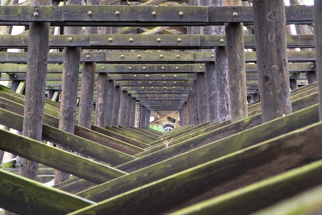
We found our target underneath a megalithic structure upon which actual live traffic continued to flow.  A short climb onto the ramp, and we were at the beginning of our journey.

Abandoned exit

Our path was choked with garbage and debris, relics of ancient ceremonies known as “benders”.  We then found ourselves obstructed by millennia of thick vegetation, grown out of control as the jungle gradually absorbed the ancient structures.

Willow blocking highway entrance

We brandished imaginary machetes and hacked our way through to sunlight.  We looked back for a brief moment, then continued north.

No way out

An ancient road lay before us.  Paved with mortar, weathered by years of rain and lichen growth, but still in excellent condition.  And wide, many shoulders wide, enough for two or even three chariots to pass each other at high speeds.  Clearly the work of skilled craftsmen, not cheap laborers, conscripts or (god forbid) a labor union.

Road to nowhere

At this point, we began to see ominous stone carvings warning us to proceed no further, etched in an archaic martial script by some forgotten king’s mandate.

No trespassing

The warnings were at times accompanied by more modern writing.  These might have been left by earlier trespassers, attempting to communicate some obscure message to those who might come after them.

C3PO

We ignored our misgivings, and continued our quest.

Blank

At length, we reached a metal gate.  It seemed like a late addition to the monumental structure, perhaps added by desperate holdouts as a defensive measure while civilization collapsed around them.  It might have served to defend precious water supplies, or perhaps to repel a hypothetical barbarian horde advancing along the 520.

Gated community

Past the fence, we encountered further writings that helped shed further light on the last dramatic moments of the collapse.  Clearly this was an important supply route during these times, perhaps the only open road from the farmlands to population centers towards the west.

Don't block

In the distance we observed a gigantic structure that would no doubt prove to be of great historical importance.  We speculated that it might serve as a site for gladiatorial games of some type, perhaps as part of some institution of higher learning devoted to the combat arts.  One of our party suggested it might be the site of an obscure ball sport believed to have been practiced in those days, but we found that theory entirely implausible.

Education

At length, we reached the very coordinates where the famous Gina IU markings had been observed by aircraft several years ago.  While some scientists affirm that the original words were part of a longer and more complex message, we remained agnostic to its actual meaning and longed for an on-site inspection.

This being the very inspiration of our current expedition, we were disappointed to find that little to nothing was left of the original etchings.  Clearly some agent beyond the usual erosive forces of wind and rain had contributed to scrubbing this primitive graffiti from the causeway.  Perhaps it had been some local catastrophe, an earthquake or mudslide.

Cement jungle

In the same area, we began to gather further clues about the fall of this ancient civilization.  Seeing the monumental structures build alongside our causeway through what appeared to be highly sensitive wetlands, we could only speculate at the creativity of the Environmental Impact Statement that could have justified such indiscriminate environmental damage.

Columns and screws

Clearly a civilization capable of this must have known no boundaries on its population growth and its thirst for natural resources. Once carrying capacity was exceeded, open warfare for precious resources must have rapidly developed between hostile tribes.

This hypothesis was immediately confirmed as we encountered a cache of primitive weaponry, perhaps abandoned to the elements after a major battle.

Rust never sleeps

Another interesting find was a metal structure whose purpose wasn’t immediately obvious.  While some in our party speculated that it might serve to facilitate the manufacture of simple textiles, others suspected a more bellicose purpose:  perhaps even some ancient type of torture device.

Cage

We found two similar forms of this artifact.  The second appeared more recent in construction, and also more flimsy – perhaps an indication that metal was becoming more difficult to obtain in later years, as local mines were exhausted and trade routes became more dangerous.

Dereliction

During our exploration, only once did we encounter any signs of native human life.  Given our observations during the expedition this far, we had become concerned that a face-to-face confrontation might result in a hostile welcome.  We were also concerned that initiating a first contact with heretofore un-contacted peoples might exceed the charter and scientific wherewithal of our expedition.

Fortunately, the natives paid little attention to us, being more preoccupied with the pursuit of what we deemed to be some intense hunting activity.  Given that such a flimsy craft could not be used for large-scale trade, we speculated that the native survivors were likely organized into small autonomous tribal encampments, using the river for transportation in times of necessity.  Surely such people would live hand-to-mouth, with little time for recreational activity or water sports.

Pristine wetland

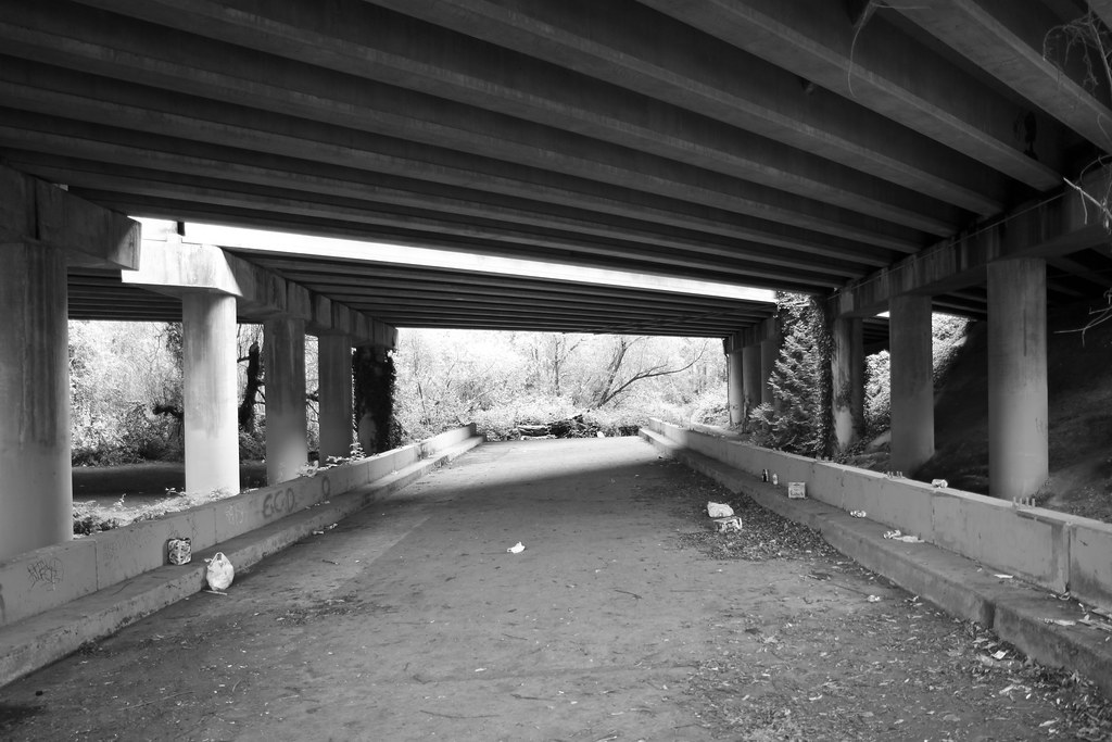
As the abandoned causeway reached its end, we felt a mixture of relief and disappointment.  We saw derelict architecture give way to well-maintained urban structures.  We heard the trappings of civilization once again begin to drone around us.  And we felt ourselves the target of some very strange looks from passing drivers.

A choice loomed before us.

We could either walk down into the populous city and again lose ourselves among the traffic, the crowds and the mercantilist bustle.  We might even be able to make it to the Montlake bus stop.

Or we could turn around and walk back, through the silent echoes and stillborn dreams of aborted urban development, trespassing again upon the sleeping authority of the forgotten highway builders.

It did not take us long to agree that the latter seemed by far the better option.

Abandoned entrance

The complete Flickr set.

Enatai Beach Park

Sometimes it isn’t the location.  It’s the timing.

Enatai Beach fishing pier

On a day I would have otherwise forgotten, I found myself exploring a park whose official description is limited to an address, a photograph of a non-descript building and instructions on how to rent the park.

I-90 sunset

I had low expectations.  My primary interest was to see what the underside of a highway might look like.

I wasn’t disappointed.

I-90 sunset

I can’t quite explain it, but there’s something I like about infrastructure.  Especially unassuming infrastructure.  Things we built to perform a function, not to serve any ephemeral standard of beauty.  Things that we maintain and keep polished because they do something for us, not because our souls find joy in gazing upon them.  For some reason, these things strike an aesthetic chord.

In a world where by any reasonable measure, the ugly outnumbers and outweighs the beautiful, a highway is the triumph of the ugly.  It’s an overt monument to dominance, to anti-nature.  It’s an industrial revolution that is also deeply counter-revolutionary.  I should have every reason to be revolted by such a scar on the landscape, and yet often I am fascinated.  There may be a Darwinian element to this appreciation, a recognition of fitness and adaptation.  Or perhaps something Hegelian, an understanding that like the Tyrannosaur or the Humvee, the I-90 exists because it must exist and there was no possible alternative to it coming into being.  Better to admire than to live in indignation.

Or perhaps there’s simply a fine line between the gorgeous and the hideous.

I-90 sunset

I-90 sunset

In addition to the I-90 bridging its way to Mercer Island, there’s also a fishing pier at Enatai.  And this is where timing comes in.  In the space of minutes, a location with no purpose but to prohibit anything fun…

Enatai fishing pier

… becomes something halfway between Kenai and Fiji.

Enatai Beach fishing pier

Fishing pier

And at the right moment, a building that is to design as a spork is to utensils manages to be something more.

Enatai silhouettes

Enatai light

I returned to Enatai the following weekend.  The place was the same, but the light had gone.

Had I had not seen its perfect moment, I wouldn’t have given it another glance.

Enatai fishing pier

The complete Flickr set.

Aurora Bridge

We didn’t discover the Aurora Bridge.  But we did walk across it the evening before WSDOT began building a new fence.

The old fence was relatively short, which made for a somewhat precarious-feeling walk from Fremont to Queen Anne.

Aurora bridge pedestrian walkway, north side

Yikes, we said.

Aurora bridge guard rail

But as it turns out, short fences and a 180-foot fall also make the Aurora Bridge popular with people looking to commit suicide.  According to Wikipedia, there have been over 230 successful suicides from the bridge, the first being a distraught shoe salesman in January of 1932.  A harbinger of things to come, because at the time the bridge was still under construction.

Walking across the bridge, the suicide theme is disturbingly prevalent.

A somber warning

Suicidal in Seattle

While it’s difficult to evaluate its effectiveness, the suicide hotline sign had a detached bureaucratic smell about it that left us wondering whether a better caption might have been something along the lines of Are you fucking kidding me?

And of course, nothing says don’t jump like the Space Needle.  Especially when it brings its friends, some nondescript Seattle high-rises.

But then something caught our eye.

Ninth life

Dried flowers, duct-taped to a light pole.  A heart.  Thank you for being.

A simple lament, taken together.  Ambiguous, even;  were they even the work of the same author?  Either way, we thought about the ones left behind, and then the scene punched us in the gut.

We didn’t jump.

We decided that while the new eight-foot fence, funded at $1.4M by Governor Gregoire, would ruin a magnificent view, it was probably a good idea.

And a magnificent view it was.  Of Lake Union and its houseboats, of downtown Seattle and its skyscrapers, of Gasworks Park and its… gas works.  All splashed with warm sunlight from a lengthy golden hour.

Seattle across Lake Union

Even Mount Rainier made an appearance, hiding nonchalantly in the bushes above the city.

Seattle across Lake Union

Thanks to its height, the Aurora Bridge is one of the few bridges in Seattle that wasn’t inexplicably designed to interfere with passing ships, and therefore require a drawbridge. Which makes it a great place to watch lesser bridge, such as the Fremont bridge, decide whether to infuriate ships or cars, or perhaps both at the same time.

Fremont bridge opening

It’s also a great place to wonder whether Adobe Lightroom would be a better program if it provided high dynamic range functionality out of the box, thus saving thousands of skies from being blown out.  Like this one.

Rust and Adobe

The Aurora Bridge itself is beginning to show its age.  While sturdy enough to merit a passing 55.2% grade from the FHA’s national bridge inventory, it was declared functionally obsolete and of better than minimum adequacy to tolerate being left in place as is.

In years to come, I can only hope my wife is able to say the same thing about me.

In any case, this means that in bridge years, the Aurora Bridge is now, officially, middle-aged.  And it shows.

Rust never sleeps

Which raises the question of why Roman bridges last two millennia, but ours get old after eighty years.  Maybe we need to take better care of our infrastructure.

Playing his last hand

So we walked the span of the bridge and then back, crossing underneath Aurora Ave and playing a game of Tetris along the way.

The mindless pattern

As we left the bridge, we were gifted with a wonderful summer sunset over the ship canal.  It’s possible that we were the last to enjoy this sight without a view obstructed by fencing.

At least, I hope we were.

Ship canal sunset

The complete Flickr set.

Walker Rock Garden

What if Antoni Gaudí had grown up in West Seattle in the 1950s, instead of 19th century Cataluña?  What if he worked as a mechanic for Boeing, instead of building gothic churches?

You might get something like this:

Walker Rock Garden

Milton Walker was a Boeing mechanic who used stones, geodes, petrified wood, and colored shards of glass to create a miniature sculpture garden in his backyard.  Milton and his wife Florence worked on this for twenty years, creating (among other things) an 18-foot bell tower, ornate fountains, a scaled-down rendition of the Alps, a gorgeously paved fireplace area with seating, and a number of butterfly-themed mosaics.


Walker Rock Garden

Walker Rock Garden

It’s actually difficult to do the Walker Rock Garden justice using photographs. You really have to see it for yourself close up.  Examine the river rock color gradients, the well-placed shards of glass.  Everything in its right place.  And so much labor and focus, invested in the design and construction of something that (sadly) appears to lack any significant commercial value. In that sense, Walker’s work is a throwback to a bygone era, a time when art existed for its own sake, born of passion or a passionate maecenas and brought into being with singular focus, as if nothing else mattered.

Walker Rock Garden

In a sense, the Walker Rock Garden is the antithesis of modern art and design.  It resists the urge to make art saleable, to optimize the means of production, to produce new discardable work ever more rapidly, to strip design down to the values of mass production, to embrace planned or neglectful obsolescence, or simply to saturate the market.

In fact, none of what Walker did in his garden was efficient, necessary, marketable, or even useful.  And that is why it is beautiful.  It is a labor of love, and of genius, and it is unique.  It could never have been built any other way.

Walker Rock Garden

Walker Rock Garden

The future of the Walker Rock Garden is uncertain.  It is currently managed by Walker’s children, and is still, remarkably, free for anyone to visit.  Just close the latch when you leave.

When we visited in the summer of 2010, there was no longer any running water and the garden was overgrown with weeds.  Down the slope from the main garden area we caught hints of some more beautiful work, but it was fenced off from the public and overrun by ivy.  I later read that a "Friends Of the Walker Rock Garden" preservation group had once existed, but it was disbanded by request of the owners.

Part of me wanted to call in an airstrike of EarthCorps volunteers to help clean the place up.  Part of me wanted to pay admission.  But is that what Walker would have wanted?  Perhaps converting his labor of love into a commercial museum would be the antithesis of his message.  Perhaps it would defeat the purpose of the work.

So we left a donation and closed the latch behind us.  It was a beautiful Seattle summer day.  No one else was around.

Mandrill face

The complete Flickr set.

Wilburton Trestle

The Wilburton Trestle is a wooden train trestle on the East Side, just southeast of downtown Bellevue.  According to Wikipedia, it’s 102 feet high and 975 feet long, which makes it the longest wooden trestle in the Pacific Northwest.  Although it belongs to BNSF, like most of the railway infrastructure in these parts, it hasn’t been used since 2007, when the Spirit of Washington Dinner Train went out of business.

Did I mention it’s made out of wood?

Wilburton trestle

Wilburton Trestle


Aside from walking under it, there are two ways to approach the trestle.  The first involves a climb up a steep muddy slope to the south side of the trestle.  This path involves pathfinding through a thicket of Himalayan Blackberry, while probably trespassing in some unsuspecting neighbor’s yard.  However, it offers a fine view of downtown Bellevue and, if you’re there at the right time, a nice romantic sunset view.

Wilburton trestle track

(If you can persuade your significant other to risk the mud and brambles, that is…)

Wilburton trestle track

The second is simpler:  park somewhere around 118th Ave SE & SE 5th St, ignore the sign promising DANGER, and walk along the tracks until you reach the north side of the trestle.

Danger

Walking the trestle from here is fairly dangerous and is clearly not for the acrophobic.  My constant companion couldn’t make it more than ten paces out.  The wood feels flimsy, and has enough gaps between the slats that the ground below is always visible.  The handrail consists of two flimsy wires, and there are pools of tar in places.  In short, it’s exhilarating.

Train's-eye view

One step beyond

The future of the Wilburton Trestle is unclear at this point.  It will likely depend on what happens with the proposed new light rail line that will connect Bellevue to the rest of the Sound Transit line sometime in the distant future.

Last train to Bellevue

Rumor has it a new trestle may be built to handle a local light rail line, with the old trestle kept around and used as a pedestrian path for hikers.  If confirmed, this would be a great use of a beautiful historic structure.

End of life

The complete Flickr set.