Group Health Overlake Center

In 1871, Warren Wentworth Perrigo and Captain Luke McRedmond became the first white men to stake a claim and settle the land that would become the city of Redmond.

Group Health Overlake siteGroup Health Overlake site

Like much of the Northwest Territory back then, the area was covered by a primeval Douglas fir forest. The trees were so large that attempts to fell them using the state-of-the-art logging equipment failed; the trunks first had to be burned. The thriving Sammamish River was thick with salmon like a grizzly bear’s dream, and so the settlement was initially called Salmonberg.

Park trailGroup Health Overlake site

Then came the loggers, the steamboats, the train tracks, the lumber mills, the cattle ranchers, the blackberry patches, and the river straighteners. Business as usual arrived, wearing a greatcoat and wielding a bible, an axe and a plow. Repeated ad nauseum, Salmonberg became Redmond.

It was the same story as everywhere else, the singular karma of the Euro-American psyche manifested yet again. And so an idyllic setting quickly became ordinary.

Tall Douglas firGroup Health Overlake site

A century later, Redmond was still a small town in a largely pastoral landscape. As late as the 1940s, the population was well under a thousand. The salmon had largely disappeared, thanks to flood control measures and lowered water levels from the Lake Washington Ship Canal project. But a lot of forest remained.

This was before the 520 bridge; before Microsoft sank its roots into the area; before Nintendo, Honeywell, General Dynamics and a thousand other employers followed.

At the time, Redmond called itself the Bicycle Capital of the Northwest, blissfully unaware that a second great land grab would soon begin: the future would not be bicycles, but American dream of SOV suburbia. Just like everywhere else.

Mature madroneMadrone silhouette

In 1977, a new hospital was carved from the forest above Lake Sammamish. Twenty eight gently sloping acres on a hill became the site of Group Health Cooperative’s Overlake site. The development created a set of buildings and parking lots while preserving the woodland setting. The site was used as a model for other commercial development in Redmond, including Microsoft’s own conversion from wooded lot to corporate campus.

Madrone, Douglas fir and cherry treesOregon grape about to flower

Thirty years and many patients later, the Cooperative moved to shinier new facilities near Bellevue’s downtown, leaving the Overlake site largely abandoned. As the needles accumulated in the parking lots and moss grew on the roofs, a development plan gradually took form, largely outside public view.

Moss with Douglas firs

Abandoned path

The City of Redmond has a plan for the area. It wants to raise a new urban village in the Overlake area; a high density urbanization and shopping center next to the city’s largest employer, adjacent to a major highway and a future light rail station. New streets, a new 12-story hotel and conference center, ten to twelve high-rise apartment buildings containing 1,400 residences, 1.4 million square feet of new commercial space. This is a developer’s dream and an environmentalist’s happy medium, using prime real estate to its fullest potential.

What could go wrong?

A building in a forest

Redmond’s zoning code requires that developers preserve a minimum of 35 percent of trees larger than 6 inches in diameter, and 100 percent of trees larger than 30 inches in diameter. The Group Health site contains 1100 trees. The large majority are over 6 inches, and there are 65 massive landmark trees estimated to be between 150 and 250 years old.

In December of 2011, the Redmond city council granted an exception to this code and approved a plan from Group Health that would cut down every single tree on the lot.

Douglas fir treesMarked for destruction

Mitigating factors in the plan included a few hundred street trees, a three-for-one promise to plant young trees in various existing Redmond parks, and plans to build a 2.67 acre park on-site that would potentially preserve some existing trees.

Unfortunately, mitigations along these lines have proven inadequate again and again. Once you cut down a stand of 250-year old trees, they’re gone.

Salal with railing

Needless to say, these new developments raised a furor. After citizens protested at a contentious council meeting in which they were largely ignored, an appeal was filed in King County’s Superior Court. Plaintiffs include Citizens and Neighbors for a Sustainable Redmond, Mayor Emerita Rosemarie Ives (16 years mayor of the city), Friends of Overlake Village, Villa Marina Condominium Association. The appeal was also supported by local organization including Eastside Audubon Society, Sherwood Forest Community Club and Techies for Trees.

Group Health Overlake siteYoung madrone with Douglas fir

Their concerns include the opaque process that led to the plan’s approval, the sea of asphalt that would result from essentially clear-cutting the last semi-forested area in Overlake, and of course precedents for future development. Their strongest legal argument, aside from the city completely ignoring its own tree retention code, appears to be a laughably incomplete Environmental Impact Statement filed by the developers. The EIS essentially ignores the fact that 1100 trees are being cut down, and makes no mention of vegetation removal nor impact on wildlife.

Oral arguments in the case begin June 25 of this year.

Group Health Overlake siteThe path is blocked

So why are the trees being removed? The official explanation is that the trees’ root systems will be weakened by development: removing existing pavement, removing some of the trees, digging utility lines, constructing underground parking lots, installing new roads. Large trees with weakened root systems might be toppled by wind storms, causing damage to the development.

A simpler explanation is that the trees are just in the way. Tap roots or no tap roots.

As one Redmond City councilmember put it, “we’ll have forests where there should be forests and we’ll have development where there should be development.”

Stop

The sad thing is that a high-density, walk-to-work urban setting is a fantastic idea for this neighborhood. With the area’s blighted strip malls and declining retail stores, there is actually plenty of space for such a revitalization. The property just across Bel-Red road is a vacant mall, containing no trees whatsoever. The next one over is an abandoned nursery that has been sitting undeveloped for years. Together they represent about 25% of the developable space on the Group Health site, and would a perfect complement to an actual sustainable development plan across the area. And down the hill are even more strip malls, just waiting to be redeveloped.

Unfortunately, most of this land falls within the boundaries of the city of Bellevue, Kemper Freeman-ville, which would never allow such development to compete with its crown jewel, the utterly unbreathable Bellevue Square.

And so we have this plan.

Overgrown buildingCherry tree

Even despite all this, given the location, it would actually be pretty simple to just let it go – that is, if the city of Redmond hadn’t already developed the living daylights out of its old forests and farmlands.

Urbanization by urbanization, what was once a beautiful landscape became acres upon acres of poorly built McMansions, laid askew on blighted developments plots designed by people who were just in it for the quick money. You don’t even have to drive around to see it; just look at the satellite map while remembering what the place was once like. Much of the new development is recent.

So business as usual has been here all along. It probably never left.

Which leads to an obvious conclusion: re-developing Overlake is a great idea, but it should not be done the usual way – i.e. clearcutting the place with zero accountability. Perhaps we can avoid business as usual, just this once.

Landscaping

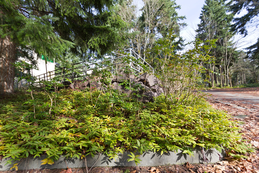
If you live in Redmond, you might consider dropping by the site one day. It’s a lovely walk, as you can see by the photos in this blog entry. While you trespass on the abandoned hospital grounds, decide for yourself whether it all needs to be destroyed in order to be saved.

So what can you do?

  1. Contact your city council. Decide whether they’re correct, misguided, or corrupt.
  2. Contact the Group Health Cooperative Board of Trustees, e.g. by sending email to governance@ghc.org. It would be a shame if their hitherto sterling reputation were tarnished with the perception of an abysmal environmental record.
  3. Donate to Citizens and Neighbors for a Sustainable Redmond, in order to help them finance the appeals process. Our legal system makes it challenging to see a case like this through without sufficient funding, and that’s likely what Group Health is counting on in this case.

To donate, you can send checks payable to Citizens and Neighbors for a Sustainable Redmond to the following address: Sustainable Redmond, PO Box 2194, Redmond, WA 98073. (Note that they’re not yet a 501(c)(3).)

Group Health Overlake site

The complete Flickr set.

Skagit County’s derelict barns

The Skagit Valley is one of the most important agricultural areas in the United States. It’s also just an hour’s drive from the Seattle area, and a wonderful place to find (among other things) derelict barns.

Abandoned barn

It is said that half of the spinach, beet and cabbage seeds used in the country are grown in the valley. Skagit farms grow over $300 million of crops, livestock, and dairy products on just 100,000 acres of land.

Abandoned barn

The Skagit was settled by European Americans in the second half of the 19th century, after some fifty years of occasional exploration due to the fur trade. The settlement process itself was relatively peaceful, with relatively few instances of violence between natives and whites. However, the newcomers came accompanied by silent killers. The Skagit tribes were decimated by smallpox in the late 19th century, largely settling any further question of land ownership.

Abandoned barn interior

Today, the Skagit River delta is lush expansive farmland, with only small patches of forest. In the 19th century, however, the same area was a classic river delta: mud flats, salt marshes and patches of dense forest. The transformation of the land was largely achieved by hand.

Abandoned barn windowAbandoned farmhouse interior

During the settlement days, each pioneer was responsible for staking his claim over an area of marsh, then painstakingly building dikes around that land. This was pure backbreaking labor, without the benefit of machinery: just a man, his shovel, and his wheelbarrow at low tide.

Abandoned farmhouse interior

Today the delta remains a floodplain, but now both forks of the Skagit river itself have been diked. Flooding is an occasional problem,but so far the land reclamation gamble has been paying off for the Skagit farmers. The resulting land, of course, has been incredibly productive, as river delta soil often is.

Abandoned barn roof

In addition to farming, logging, mining and railroad construction also drew laborers and settlers to the nascent Skagit towns. Not every town was successful, however. Driven largely by bribery, the railroad routes determined to a large extent where the larger population centers would develop.

Abandoned farmhouse roof

In many cases, settlements were fueled only by imagination. On Samish Island, the town of Atlanta was founded by a Confederate veteran, designed as a "sanctuary of persecuted Confederates and other sympathizers with the lost cause." Next to Atlanta, a Unionist founded Samish, and the two towns rivaled each other in various economic endeavors to the point of violence.

Samish Island today is a sleepy little hamlet with little visible trace of this not entirely ancient feud.

Abandoned truck and pipe

In the early pioneer days, one of the greatest challenges of life was finding a wife. The Skagit was no exception, and those pillars of pioneer life, the whorehouse and the mail-order bride, were no strangers to the valley.

Derelict barnDerelict barn

The original Washington Territory prohibited interracial marriages between whites and natives. However, this did not prevent many settlers from marrying native women in native ceremonies. As white women gradually colonized the Skagit, not all of these arrangements ended well. When Washington was incorporated as a state in 1889, interracial marriages were grandfathered into legality, but only after requiring that they be legally formalized before the authority of the state.

Derelict barn

As the story goes, one settler refused to engage in the second ceremony, due to concerns that his children would be seen as illegitimate. He was indicted for this small act of resistance, although later acquitted.

Derelict barn

For the casual visitor, the Skagit looks first plain. Strip malls, casinos and outlet stores along I5 paint a garish picture of the area, as do the numerous alpaca-related lures. The highway is a source of entrappable Canadians and Seattleites, and the drive is long. So while not pleasant, the driveby shooting of commerce is understandable.

Derelict barn

Once off the highway, however, perceptions shift. The more ludicrous appeals to your attention disappear, and the county settles down to the business of exploiting the land in a thousand different ways.

While the derelict barns call out to lens and eye alike, they are not symptoms of decay but exceptions. Instead, the tulip farms, farmers markets and weekend homes add up to a rural America that’s less desperate than optimistic. While ultimately fueled by unsustainable green revolution agriculture and tourist wealth from surrounding urban islands, the Skagit is generally a prosperous and peaceful place.

Even the tribes are doing reasonably well. After surviving a smallpox epidemic, a century of white settlement and a pair of toxic Shell Oil refineries, they continue to occupy their 1855 reservation lands. The Swinomish population has grown past 900, and their casino has been highly successful. In fact, they seem to be an entirely enterprising bunch.

Derelict barnDerelict barn

The complete Flickr set.

(And thanks to the Skagit River Journal for much of the content discussed above.)

Elliott Bay Marina

Heading north from where the Port of Seattle ends at Smith Cove, you find yourself among humans again.  The sound of conversation echoes over the water.  There is laughter, and there are flower beds and the scent of freshly mowed grass.  There are children on leashes and parents holding the hands of pet dogs.  There are ships, and the waves lap ever so softly against the dock.

This is the Elliott Bay marina.  It is a place of opulence, Manhattan to the South Park marina’s Bronx.  Located beneath the beautiful Magnolia bluffs, it enjoys a fantastic view of Seattle’s downtown.  It’s the high rent district.

And it is in every way perfect.

Seattle through Elliott Bay Marina

From the landlubber’s perspective, a marina is a symmetric jumble of impractical vessels.  From small pleasure boats to larger liveaboards, they lack the blue-collar ethic of the fishing boat, or the single-minded purpose of the cargo ship.  They are entirely optional, an indication of perhaps entirely too much wealth, or perhaps of a set of priorities and lifestyle choices that befuddle and confuse the poor landlubber.

In that light, you would be justified in asking ask why these ships are here.  Who pays the rent, and why?

Elliot Bay Marina

Interesting though these questions might be, this story is not about the luxury tax, the call of the waves, or the jet-setting lifestyle of the modern yacht mariner.

Nor is this story about the attempted poisoning of pesky but adorable otters, which prompted an indulgent but stern rebuke from the marina’s manager. This is a different story entirely.

As it turns out, the story of the Elliott Bay Marina is about fishing rights.

Elliott Bay Marina reflections

Like most stories, it’s but a simplification of a simplification.  The complexities of life evade simple description.  Everything but the bare essence is lost in the telling.

Pier 91 reflections

The story begins with the Treaty of Medicine Creek.  It’s December of 1854 in the remote territory of Washington.

Territorial Governor Isaac Stevens is a former military man, hell-bent on a land grab of historic proportions.  His title includes the honorific "Superintendent of Indian Affairs" and he is clearly living the dream.  When the tribes don’t respond to intimidation, he calls in the military.  When white citizens oppose him, he arrests or discredits them.  He is on a mission to civilize this heathen part of the god-given earth.

At Medicine Creek he gathers the leaders of the Nisqually, the Puyallup and the rest of the tribes of Western Washington.  For the princely sum of $32,500 and some reservation land, over two million acres of land are signed off to the United States government.  With a native population of just 6,000, resistance is futile and they know it.  It’s an offer they simply cannot refuse.

It’s a moment that will leave long scars on their future.  In their minds eye, the shining cities to come have already begun to cast a shadow.  Not theirs anymore, never again.

Seattle from Elliott Bay Marina

As an afterthought, the treaty grants the natives the right to fish.

The right of taking fish, at all usual and accustomed grounds and stations, is further secured to said Indians in common with all citizens of the Territory.

For those of us who buy never-frozen wild salmon from behind the counters of large industrial organic establishments, the dirty business of catching the damn things is forever hidden.  Nevertheless, this is a generous grant indeed.  Perhaps Governor Stevens is after all a humanitarian.

It is worth recalling that in 1854, the Nisqually could throw a rock at water, and a grilled salmon would float to the bank.  Fish and game were effectively limitless at the time, in a way that neither we nor our descendants will ever understand.  The treaty could have granted the natives the right to breathe, and it would have been no more surprising.  The only surprise is that it was included at all.

It’s tempting to imagine an enterprising chief slipping this clause past the white man’s careless lawyers, with another seconding the motion and a third moving to commit.  We’ll never know.  The minutes of the meeting are lost, and the establishment of such rules of order were twenty two years in the future.  All there was at Medicine Creek was the order of the gun.

Elliot Bay Marina

So the Nisqually tribe packs up and leaves for the reservation.  It’s on rocky ground, and there’s no good way to grow food.  It’s also cut off from the river, so there’s no good way to fish.  The long starvation begins.

The next year, chief Leschi goes to Olympia to protest the terms of the treaty.  He claims his signature was forged and he had refused to sign.  The powers that be react violently and Leschi has no choice:  it’s time to think the unthinkable, and rebel against the state of Washington.

One thing leads to another, and we get the Puget Sound war of 1855-1856.  Unsurprisingly, the full force of the US military and local militias are brought to bear, and the revolt is suppressed.  While few actual deaths result from the war, the native uprising is a shock to the settlers.  One might argue that at this point, the natives were lucky they weren’t exterminated.

Meanwhile, chief Leschi is on the run and Governor Stevens is having paranoid fits. He suspects some settlers of helping Leschi, and he goes to the length of declaring martial law in Pierce County. Eventually he catches up with Leschi and tries him in various kangaroo court until it sticks. His half-brother and co-conspirator Quiemuth comes forward to try to save his brother, and he’s murdered in Steven’s own office while in custody of the state. Leschi’s conviction takes him to the gallows, and he’s hanged for murder he probably wasn’t present to commit.

Olympic Mountains sunset

By 1880, the Nisqually tribe has shrunk to 700 people, down from over 2,000 at the beginning of the century.  Their access to the salmon runs has became illegal banditry.  The state government is of the white extractive industries, for the white extractive industries.  Rivers are haphazardly closed, and various forms of fishing are banned, conveniently those used by the natives.

Meanwhile, civilization grows.  Rivers are dammed, forests are logged, and industrial-scale fishing is making a dent in limitless but fragile resources.  The salmon runs dwindle, and of course native poaching is blamed.

Two subsequent court cases illustrate the themes of the time.

In 1905, a federal court decides the US vs. Winans case in favor of the natives, reaffirming the rights of the Yakama tribe to fish in local rivers.  However, it allows the state of Washington to reasonably regulate this fishing in the interests of conversation.  The State of Washington, never one to miss a trick, makes a river of lemonade and interprets the ruling as carte blanche to continue to enforce its laws regarding licenses, fishing methodology restrictions, and river closures.

In 1916, in the State vs. Towessnute case, State Supreme Court Justice Bausman effectively reverses Winans, writing the following words for the record:

The premise of Indian sovereignty we reject. The treaty is not to be interpreted in that light. At no time did our ancestors in getting title to this continent ever regard the aborigines as other than mere occupants, and incompetent occupants, of the soil. Any title that could be had from them was always disdained… Only that title was esteemed which came from white men… The Indian was a child, and dangerous child of nature, to be both protected and restrained. In his nomadic life, he was to be left , as long as civilization did not demand his region. When it did demand that region, he was to be allotted a more confined area with permanent subsistence… These arrangements were but the announcement of our benevolence which, notwithstanding our frequent frailties, has been continuously displayed. Neither Rome nor sagacious Britain ever dealt more liberally with their subject races than we with these savage tribes, whom it permitted to squander vast areas of fertile land before our eyes.

Two other state court cases that year went along the same lines.  Presumably demoralized, none of the tribes appeal to the US Supreme Court.  Native fishermen continue to ply their trade, but are increasingly subject to the whims of local law enforcement.  Most traditional means of fish harvesting are now illegal, including spearing and gaffing.

In effect, life and tradition itself is now illegal.

Seattle through Elliott Bay Marina

By the 1960s, native access to the salmon runs has become a civil rights issue, and a cause célèbre of Marlon Brando and others.  Civil disobedience is in the air, as is violence.  The state continues to enforce its laws.  In September 1970, Tacoma police arrest and beat 59 protestors on the Puyallup river, using tear gas, clubs and live ammunition to restore law and order.  Finally, the feds step in.  That same month, the US government files United States vs. Washington.

The honorable George Boldt presides.  He’s a conservative Eisenhower appointee in his late sixties, and a sports fisherman himself.  The smart money shorts the natives.

The case lasts three and a half years.  Boldt listens.  He hears state officials and tribal elders.  He reads the treaty.  Signed in haste and under duress, it’s the only thing that can protect the natives now.  Boldt consults his copy of the 1828 Webster’s American Dictionary.  He writes 203 pages worth of decision.

Flags at Elliott Bay Marina

The Boldt decision is a miracle or infamous, depending on your point of view.  It gives the tribes 50% of the harvestable salmon from their traditional waters, because that’s what that in common with would have meant in 1854.  In an instant, the natives are no longer bandits and thieves, but co-managers of the salmon industry.

Attorney General Slade Gorton appeals all the way up to the US Supreme Court, but to no avail.  His family’s fish stick fortune is no conflict of interest, and he later spends his golden years in the company of an even greater band of thieves, the US Senate.  Washington’s tribes and its fishing industry reach an uneasy equilibrium, which lasts to this day.

But what of our fair marina?

Elliot Bay Marina

As it turns out, the Elliott Bay marina was built in the accustomed fishing grounds of the Muckleshoot and Suquamish tribes.  When the initial development plans became public, the tribes sued.  Using Boldt as precedent, a US District Court granted a quick preliminary injunction against the marina’s development.

Furious settlement activities followed, and an agreement was reached that allowed the marina’s development to proceed while compensating for the lost fishing.  A percentage of the marina’s gross revenues are now paid directly to the tribes, which by my rough calculations might amount to over a quarter million dollars every year – a bit more than what the court document say was coming in from fishing.  This arrangement will last for 99 years, and everyone seems happy about it, including the salmon.

The marina itself opened in 1991, and it’s reasonably environmentally friendly as marinas go. It doesn’t use creosote pilings, and its rock breakwater channels allow kelp to grow and juvenile salmon to migrate.  If salmon runs are threatened in this area and all around the Puget Sound, it’s probably not because of this marina.  While it may be because of countless shoreline developments just like it, you can’t blame the knife for the thousand cuts.

And if a century later the tribes will be down one more natural resource, well, that’s not a problem for the present.  Maybe investing the money will pay off more than the fishing ever did.

One last detail:  every time a yacht pulls into the Elliott Bay marina, there’s a line item in its mooring charges named the "Indian Surcharge" – called out explicitly out of pique, out of honesty, or perhaps out of legal requirement.  It’s a living tribute to a vivid history that would otherwise have gone completely unnoticed by this storyteller.

Olympic Mountains sunset

The complete Flickr set.